


Go Track Free
توضیحات Go Track Free
Go Track is mobile client for OpenGTS open source project. It is designed to view last GPS position of the devices configured in OpenGTS and also view the trail of the device in map.
Go Track app is designed to show the standard icons comes with default OpenGTS server. Customer who have customized PushPin Icons in OpenGTS server, will not be view their customized PushPin Icons in Go Track app. The customized icons will be shown as black icons.
We have developed www.GoTracky.com for customers to easily rebrand GoTrack app based on Company Name, Logo and Color Theme. Also, the rebranded app will be able to integrate customized PushPin Icons in customer's OpenGTS server.
OpenGTS™ ("Open GPS Tracking System") is the first available open source project designed specifically to provide web-based GPS tracking services for a "fleet" of vehicles (http://www.opengts.org).
This FREE version is ad supported and limitation of viewing 3 vehicles. Free rebranded app via www.GoTracky.com shows all devices.
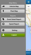
Features:
- View vheicles configured in OpenGTS.
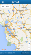
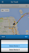
- View most recent position of the vehicle in Map.
- View all vehicles and last position in Map.
- Search for vehicle track based on date.
- Manual and auto update of vehicle position and track (update every 1 minute)
Configuration:
- In settings page, configure the OpenGTS server URL.
http://www.mydomain.com/track/
- Set track.enableAuthenticationService to true in private.xml.
Version 4.4
- Changed Google Map to Openstreet Map
- Issues fixed
Version 4.3
New Features and Issued fixed:
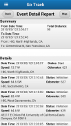
- Two new reports added - Event Detail and Speed Report
- Refresh device list when changing account, i.e. logout and login with another account.
- Option to search for Device in Device List
- In Settings, OpenGTS URL will be defaulted to http://, to facilitate faster entry.
Version 4.0
1. Fixes to work with latest version of OpenGTS.
New Features:
1. Sliding Menu for easy navigation.
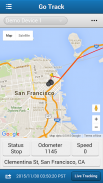
2. Vehicle Latest location information such as Address, Speed, Odometer and Status (such as Start, InMotion or stop) is shown in Vehicle Map.
3. Locate feature in Vehicle Map to display the users current location.
4. When a vehicle is lost, Vehicle Latest location information, Live Tracking and Locate feature in Vehicle Map is useful to track and follow the vehicle based on user's current location.
Reports Enhancements:
1. Report display is optimized for easy viewing of report details.
2. Event Detail Report show summary such as Total distance travelled (based on Odometer), from and to address.
3. Event Detail Report information can be viewed on Map.
Version 3.2
Issues Fixed in this version:
- App not working in Android 4.x
- Apps crashes when physically turning the mobile from portrait to landscape (or the other way around)
- Search result will remove the existing track on the map.
- Marker bubble: clicking on new bubble will remove the old bubble. Also, the bubble will automatically removed after 30 seconds.
Version 3.1
Issues Fixed:
- Data persistence issue (entering OpenGTS URL every time to run the apps)
New Features:
- In vehicle list, added last event address and date time.
- In Group Map, auto zoom to show all the vehicles.
- In Settings following options will be added:
- Limit no of data points in Vehicle Map.
- Show/hide the markers in Vehicle Map.
- Show/hide the route arrow in Vehicle Map.
Version 3.0
Fixed the problem with Login Failure issue.
Version 2.0
Removed the Camera permission.
برو آهنگ مشتری موبایل برای پروژه OpenGTS منبع باز است. این برنامه برای مشاهده آخرین GPS موقعیت دستگاه های پیکربندی شده در OpenGTS و نیز نمایش مسیر دستگاه در نقشه است.
نرم افزار Go Track طراحی شده است تا نشان دهد آیکون های استاندارد با سرور OpenGTS پیش فرض همراه است. مشتریانی که آیکون PushPin را در OpenGTS سفارشی کرده اند، آیکن PushPin سفارشی خود را در برنامه Go Track مشاهده نخواهند کرد. آیکون های سفارشی به عنوان آیکون های سیاه نمایش داده می شوند.
ما www.GoTracky.com را برای مشتریان به راحتی برنامه GoTrack را براساس نام شرکت، لوگو و تم رنگی بازاریابی کرده ایم. همچنین، برنامه بازاریابی قادر به ادغام سفارشی آیکون PushPin در سرور OpenGTS مشتری است.
OpenGTS ™ ("باز کردن سیستم ردیابی جیپیاس") اولین برنامه منبع باز موجود است که به طور خاص برای ارائه خدمات ردیابی GPS مبتنی بر وب برای "ناوگان" وسایل نقلیه (http://www.opengts.org) طراحی شده است.
این نسخه رایگان آگهی پشتیبانی می شود و محدودیت مشاهده 3 وسایل نقلیه. برنامه بازاریابی رایگان از طریق www.GoTracky.com همه دستگاه ها را نشان می دهد.
امکانات:
- نمایش vheicles پیکربندی شده در OpenGTS.
- آخرین موقعیت خودرو در نقشه را ببینید.
- مشاهده تمام وسایل نقلیه و آخرین موقعیت در نقشه.
- جستجو برای مسیر خودرو بر اساس تاریخ.
- دستی و به روز رسانی خودکار موقعیت خودرو و مسیر (به روز رسانی هر 1 دقیقه)
پیکربندی:
- در صفحه تنظیمات، URL سرور OpenGTS را پیکربندی کنید.
http://www.mydomain.com/track/
- track.enableAuthenticationService را در private.xml درست کنید.
نسخه 4.4
- گوگل نقشه را به Openstreet Map تغییر داد
- مسائل ثابت شده
نسخه 4.3
ویژگی های جدید و نسخه های ثابت:
- دو گزارش جدید اضافه شده - جزئیات رویداد و گزارش سرعت
- تغییر لیست دستگاه هنگام تغییر حساب، یعنی خروج از سیستم و ورود با حساب دیگری.
- گزینه ای برای جستجوی دستگاه در لیست دستگاه
- در تنظیمات، URL OpenGTS خواهد شد به http: // پیش فرض، برای تسهیل ورود سریع تر.
نسخه 4.0
1. رفع به کار با آخرین نسخه OpenGTS.
ویژگی های جدید:
1. منوی کشویی برای ناوبری آسان.
2. وسیله نقلیه آخرین اطلاعات مکان مانند آدرس، سرعت، کیلومتر شمار اتومبیل و وضعیت (مانند شروع، InMotion یا توقف) در نقشه خودرو نشان داده شده است.
3. ویژگی را در Map Vehicle برای نمایش مکان فعلی کاربران تعیین کنید.
4. هنگامی که یک وسیله نقلیه از دست رفته، وسیله نقلیه آخرین اطلاعات مکان، ویژگی پیگیری زنده و تعیین موقعیت در نقشه خودرو مفید است برای ردیابی و پیگیری خودرو بر اساس مکان فعلی کاربر.
گزارش های پیشرفت:
1. نمایش گزارش برای مشاهده آسان جزئیات گزارش بهینه شده است.
2. گزارش جزئیات رویداد خلاصه ای از قبیل فاصله کل سفر (بر اساس کیلومترشمار)، از و به آدرس را نشان می دهد.
اطلاعات گزارش رویداد Detail را می توان در نقشه مشاهده کرد.
نسخه 3.2
مسائل ثابت شده در این نسخه:
- برنامه در Android 4.x کار نمی کند
- برنامه های کاربردی هنگامی که به صورت فیزیکی تلفن همراه را از پرتره به چشم انداز (و یا از راه دور)
- نتیجه جستجو مسیر موجود بر روی نقشه را حذف می کند.
- حباب نشانگر: کلیک بر روی حباب جدید حباب قدیمی را حذف خواهد کرد. همچنین، حباب به طور خودکار پس از 30 ثانیه حذف خواهد شد.
نسخه 3.1
مسائل ثابت:
- مسئله پشت سر گذاشتن داده (ورود URL OpenGTS هر بار اجرا برنامه ها)
ویژگی های جدید:
- در فهرست خودرو، آخرین آدرس رویداد و تاریخ زمان اضافه شده است.
- در گروه گروه، زوم خودکار برای نشان دادن تمام وسایل نقلیه.
- در تنظیمات گزینه های زیر اضافه خواهد شد:
- هیچ نقاط داده ای را در نقشه خودرو محدود نکنید.
- نمایشگر / مخفی کردن نشانگرها در نقشه خودرو.
- نمایش فلش مسیر را در نقشه خودرو پنهان کنید.
نسخه 3.0
مشکل با مشکل عدم ورود به سیستم را رفع کرد.
نسخه 2.0
مجوز دوربین را حذف کرد.
Go Track Free - نسخه 4.4
(07-12-2018)Go Track Free - اطلاعات APK
نسخه APK: 4.4حزمة: com.kpraathul.gotrackfreeآخرین نسخه Go Track Free


اپلیکیشنها در دسته مشابه

شاید دوست داشته باشید...


